Inside the giant 'sky rivers' swelling with climate change

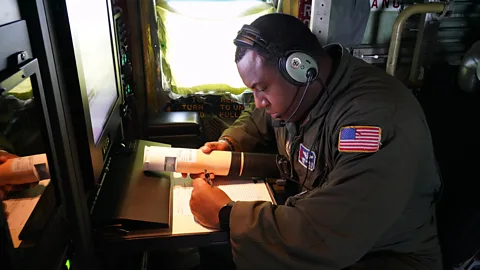
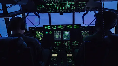 US Air Force
Atmospheric river storms have wreaked havoc on the West Coast, and are getting bigger. These scientists chase them in the sky to predict where they will strike.
In January 2024, Anna Wilson was sitting aboard a Gulfstream IV jet, observing a deceptively calm-looking sea of white clouds over the northern Pacific Ocean. Through her headphones, Wilson – an atmospheric scientist and extreme weather expert – could hear her colleague give a countdown. At the back of the plane, another colleague dropped slim, cylindrical instruments through a chute, into the brewing storm below them, to measure its strength as it approached the US West Coast.
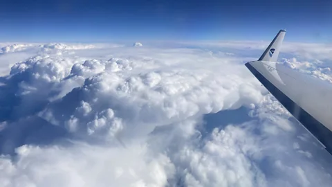
The type of storm they were tracking is known as an atmospheric river – a weather phenomenon that has been attracting more and more attention in recent years, as scientists and the public race to understand its sometimes devastating impact. Research suggests that atmospheric rivers are getting bigger, more frequent and more extreme, due to climate change; and the damage they cause is getting worse.
Often described as rivers in the sky, atmospheric rivers are a huge, invisible ribbons of water vapour. Each can be several hundreds of kilometres wide, and transport 27 times as much water as the Mississippi River. They are born in warm oceans, as seawater evaporates, rises and moves to cooler latitudes. When the vapour reaches a coast, such as California, it flows up a mountain, cools, and comes down as rain or snow – enough to wash down hillsides causing landslides, and bring torrential rain, floods and deadly avalanches.
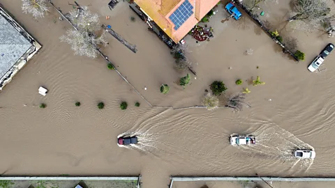
 Getty Images
On the US West Coast, atmospheric rivers bring the heaviest rains, warmest storms, major floods, extreme coastal winds, and landslides. They can come in groups – known as "families" – with several of them striking a place within days. The brewing family of storms Wilson and her colleague were flying over was in fact formed by four atmospheric rivers, which later caused heavy snowfall in California and floods in Oregon in January 2024.
The basic questions remain the same for each atmospheric river, says Wilson, a field research manager at Scripps Institution of Oceanography at the University of California San Diego. "Where is it going to make landfall? How strong will it be? How long will it last? And we continue to get better at [answering] that," she says.
The flight Wilson was on in January was part of Atmospheric River Reconnaissance, or AR Recon, a joint project with the US Air Force, the National Oceanic and Atmospheric Administration (Noaa) and other partners. Using "hurricane hunter" aircraft normally deployed for observing hurricanes – the NOAA Gulfstream jet, as well as two or more Air Force aircraft – teams of scientists fly over atmospheric rivers, and drop instruments called dropsondes into them.
"Atmospheric rivers are interesting and cool but you can't see them, actually, because it's water vapour," Wilson says. "And they're really close to the surface, they are usually focused on the lowest few kilometres of the atmosphere."
Wilson points out that they tend to travel under cloud cover, which hides them from conventional weather observation tools like satellites. "It's really hard for the satellites to sort of see through that, to what's going on at the near-surface. So the point of flying the aircraft through them is to be able to drop our sensors, and get these foundational meteorological measurements – temperature, air pressure, wind and moisture," she says.
The atmospheric rivers Wilson and her team were monitoring in January were part of a series of 51 atmospheric rivers that hit Washington, Oregon and California between autumn 2023 and spring 2024, 13 more than the previous season. Knowing when and where such a storm will arrive, and how powerful it is, helps people on land prepare for what's coming, and for example, empty the right reservoirs in time. But Wilson and her colleagues' flights, which started in 2016, are also part of a wider scientific effort to better understand atmospheric rivers – including their surprising benefits.
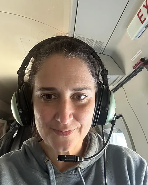 Anna Wilson
As extreme weather specialists are quick to point out, atmospheric rivers are not necessarily destructive. On the contrary, they can be life-sustaining.
"We need [atmospheric rivers] – without them in the West we have droughts," Wilson says. Up to two-thirds of the West Coast's droughts are brought to an end by the arrival of an atmospheric river – they are known as drought busters.
"There is a beneficial side of atmospheric rivers," agrees Bin Guan, an atmospheric scientist at the University of California, Los Angeles and Nasa's Jet Propulsion Laboratory. "We tend to highlight the hazardous side but we have to remember that they provide important water supply in dry regions, such as California." Overall, they contribute up to 50% of California's rain and snow.
On the west coast of the US and Canada, atmospheric rivers have been known as the "Pineapple Express" due to their presumed origins near Hawaii. However, Guan says that name is rarely used amongst experts, since atmospheric rivers are a global phenomenon, and many of the ones hitting the West Coast in fact originate much further away than Hawaii. In October 2017, an unusually long atmospheric river extended roughly 5,000 miles (8,000 kilometres) from Japan to Washington.
In 2019, researchers created a scale to rank atmospheric rivers from one (weak, producing modest rainfall) to five (exceptional, primarily hazardous) to give a more nuanced picture of them.
 Rich Henning/Noaa
"The mild ones are considered beneficial for the water supply, only the very extreme ones are hazardous," says Qian Cao, a hydrologist at the Scripps Institution of Oceanography. "So it has both good sides and downsides, it doesn't only lead to bad events here."
Predicting atmospheric rivers is key to limiting their destructive side, but is difficult, Cao says. For a start, they develop over the ocean, where there are fewer ways of observing them than on land. They then travel thousands of kilometres, and during that journey, can stall, intensify, weaken, get warmer or cooler, and interact with other atmospheric rivers, or remnants of them. Any of these changes will affect their impact, she says.
Strategies such as forecast-informed reservoir operations, which use weather and water forecasting to help water managers decide whether to empty their reservoirs in expectation of massive rainfall, can help cope with them, she says.
"If we can forecast or predict these atmospheric rivers better, if we can predict them more accurately, with longer lead times, then we have more time to make operational decisions, for example, whether we want to release water or save water in the reservoirs," says Cao. Forecasts are most accurate in the short term, for lead times of three to five days, she says, and their accuracy decreases with longer lead times. "Researchers are working very hard to improve forecasts beyond week two," she adds, since having a month or more to prepare would give people on the ground more options.
This is where the AR Recon flights come in, looking inside the sky rivers, where other instruments can't reach.
 US Air force
For Wilson's team, each flight begins with a forecast meeting in the morning, discussing existing forecasts of rain and snow in the US in the coming days. They identify areas of uncertainty that could be improved through more data on the atmospheric river that is bringing the expected rain or snow. They then fly to that atmospheric river, and collect the required data with the dropsondes.
"The purpose of these targeted reconnaissance flights is to fill gaps, when we know the satellites have a difficult time seeing," Wilson says.
Each Gulfstream flight lasts around eight hours – and as Wilson says, one vital bit of practical preparation is to bring your own food. The instruments transmit the data to the team aboard the aircraft, who check it and transmit it to the Global Telecommunications System, a World Meteorological Organization service that collects and distributes global weather-related data. It is then picked up by forecasting models, which use the data together with hundreds of millions of other observations, including from satellites. The now more accurate forecasts, enhanced by the dropsonde data, are shared with reservoir operators and emergency responders.
Studies suggest that the dropsonde data indeed helps improve forecasts, with a recent analysis recommending that future missions involve daily flights and both the Gulfstream jet and Air Force aircraft, to gather as much data as possible. The team are also using other technologies to collect information, as well as working on modelling systems, to further improve forecasts and deepen their understanding of individual storms.
This race to understand atmospheric rivers is especially urgent, researchers say, as studies suggest they are changing, and becoming more frequent – and potentially, becoming more devastating.
 Getty Images
Mengqian Lu is an associate professor in hydrometeorology and water resources at Hong Kong University of Science and Technology. She and her team published a global study in January 2024 projecting their future intensity, frequency and associated rainfall and snowfall around the world. According to their projections, the global frequency of atmospheric rivers could almost double by the end of this century. But what exactly that means on the ground varies from region to region, the study suggests.
"In general, the more frequent and stronger [the atmospheric river], the more frequent and stronger rainfall it brings – but the translation is not one-to-one because the climate system is non-linear, rather chaotic," Lu says.
What seems likely is that as the atmosphere warms with climate change, it will be able to hold increasing levels of moisture. "As a result we expect to see more frequent and stronger atmospheric rivers," she says.
Because of their role in transporting heat as well as moisture, knowing how atmospheric rivers will change as climate continues to warm up is essential for understanding the broader impact of global warming, Lu says. For instance, atmospheric rivers bringing warmth have triggered the melting of ice shelves in West Antarctica.
A growing body of research highlights their impact around the world. In East Asia, they contribute up to 90% of extreme rainfall in the warm seasons, and have caused floods and landslides. They can affect multiple locations, with several places experiencing disastrous weather at the same time, or in close succession, as atmospheric rivers might bring snow and blizzards to one region, and rain and severe floods to another.
They can also form vicious cycles with other disasters, such as wildfires, causing mudslides in areas scarred by fire where the lack of vegetation makes the soil less absorbant and vulnerable to erosion. They can also drive fast plant growth that turns into fuel for the next fire, leading to an increase in the burned areas the following season, research suggests.
 Getty Images
Back-to-back atmospheric rivers – one after the other, bringing seemingly endless rain – are also becoming more common, studies suggest. From late December 2022 to mid-January 2023, nine atmospheric rivers hit California in a row, resulting in floods, landslides and power outages. As the authors of one study point out, such clusters can mean the drenched soil cannot dry out in between the storms, making flooding more likely. (Read more about how climate change could bring megafloods to California.)
"In the western US, atmospheric rivers account for nearly 90% of the flood damages, totalling more than $1bn (£80m) a year. This number could double or even triple by the end of this century based on climate model projections of changes in atmospheric rivers," Guan says.
Nor do they always carry water vapour alone. In 2021, they drove Saharan dust from Africa to Europe, darkening the snow in the Alps, reducing its reflectiveness, bringing heat, and reducing snow depth by 50%.
More like this:
Given this global scale and complexity, how can we cope with atmospheric rivers?
Cao says we need to recognise how climate change is altering them, and adopt more sustainable development measures to fight global warming. Early warning systems, public awareness and more accurate and sophisticated forecasts are also crucial in helping us be prepared, she says – as well as understanding which weather patterns and climate conditions help generate atmospheric rivers in the first place.
Meanwhile, it may be at least some comfort to know that hundreds of dropsondes are falling through these mysterious storms each year, collecting data that makes them more predictable.
Wilson says the mission gives her hope, especially the work with responders on land, such as the emergency operations centre in California: "It's a really awesome feeling as a scientist to work on something that is so immediately applicable. This is making an impact right now for people on the ground," she says.
--
For essential climate news and hopeful developments to your inbox, sign up to the Future Earth newsletter, while The Essential List delivers a handpicked selection of features and insights.